Summerlike Temperatures To Challenge Records In Pacific Northwest
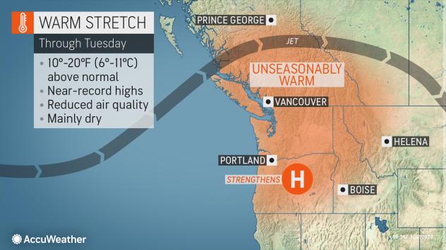
After abnormal warmth overspread much of the West Coast early last week, more typical cool and wet conditions closed out the month of September in the Northwest. However, with the up-and-down temperatures often felt in fall, AccuWeather meteorologists warn that near-record high temperatures are likely over the next few days, with conditions feeling more like August than October for many in the Pacific Northwest.
“The calendar recently flipped to October, but it certainly will not feel like fall across the Northwest,” AccuWeather Meteorologist Joe Curtis said.
Last week’s stretch of warmth would not be considered abnormal or extreme by summer standards, but was highly unusual given the current time on the calendar. From Sept. 24-27, high temperatures were often up to 20 degrees Fahrenheit above average for the time of year, and even set records in some cases. This heat was most notable in the Northwest, where high temperatures typically hover in the upper 60s to low 70s in late September along the busy Interstate-5 corridor. In Seattle, temperatures peaked in the lower 80s from Sept. 25-26. Meanwhile, no records were officially set in Portland, Oregon, but the mercury surged to 90 degrees on Monday, Sept. 26, a very rare feat for late September.
After a storm system brought cooling cloud cover and some rainfall later in the week, a return to drier weather has taken place to start October. Meanwhile, the jet stream is sliding northward into Canada, allowing what is known as a heat dome to build to the south of it. While temperatures will be far less intense than those experienced during the midsummer months, it will be more than enough to send temperatures surging to unusual levels.
“The strengthening area of high pressure over the Northwest will lead to unseasonable warmth, and for many areas, temperatures will be more typical of July than October,” Curtis cautioned, noting that temperatures would be 10 to 20 degrees above normal for most of the region.

For some, the abnormal heat began at the beginning of the weekend. Temperatures in Portland surged to 86 F on Saturday, which is 15 degrees above the normal high for the date. Similar heat is in the cards through Monday, with highs in the low to mid-80s.
In Seattle, the more northerly latitude and proximity to water may knock several degrees off the high temperature, but it will still be noticeably and abnormally warm in the area. The city will challenge daily record highs through Monday with highs set to approach 80. Record warmth will continue into Tuesday with a projected high in the middle 70s, challenging the date’s high mark from 1966 of 76.
While the most abnormal heat will be found in the Northwest, portions of California will also feel the above-average temperatures. This effect will be the strongest inland, away from the cooling influences of the Pacific Ocean.
“Toward midweek, the next storm system will push toward the West Coast, sending the jet stream southward and shifting the higher heat along with it,” Curtis explained, noting that while this system might not be strong enough to bring much rain, it could help bring a cool down.
In Sacramento, California, afternoon temperatures typically reach into the low 80s. By mid- to late week, however, low 90s will be more common, with any cooling cloud cover limited to the north and west.

Farther south in Fresno, temperatures are set to reach the mid-90s by Tuesday or Wednesday. Though far from certain, a few of the daily record highs, which are generally in the upper 90s, could be threatened.
These hot conditions in California, aren’t an everyday occurrence during the fall, but are less unusual than those that are likely to be felt farther north. Additionally, while the temperatures in California, may be above those that are felt in Oregon, and Washington, that doesn’t necessarily mean the impacts will be greater. Unlike in the Southwest, many homes farther north do not have air conditioning, making the warmth more uncomfortable and raising the chances for heat-related illnesses in the most impacted areas.
Fortunately, just like the last round of abnormally warm weather, relief should be quick to arrive.
By midweek, an active storm track should bring a quick cool down to the Northwest. While things will take a bit longer to return to normal farther south, temperatures are expected to return to more typical levels by the weekend or early next week.
Produced in association with AccuWeather.
The Western Journal has not reviewed this story prior to publication. Therefore, it may not meet our normal editorial standards. It is provided to our readers as a service from The Western Journal.
Truth and Accuracy
We are committed to truth and accuracy in all of our journalism. Read our editorial standards.
Advertise with The Western Journal and reach millions of highly engaged readers, while supporting our work. Advertise Today.


