Orlene To Become A Hurricane, Increase Flooding Concerns In Western Mexico
Tropical Storm Orlene, the 16th named storm of the East Pacific hurricane season formed early Thursday morning, and AccuWeather forecasters say the storm is on a path to bring heavy rain and gusty winds to portions of Mexico. Moisture from Orlene may even go on to work its way into the United States.
As of Thursday morning, Orlene was a tropical storm with sustained winds of 45 mph (72 km/h) and was located about 300 miles (480 km) south-southwest of Manzanillo, Mexico. Orlene was a rather compact storm, with tropical-storm-force winds reaching 35 miles (55 km) outward from its center.
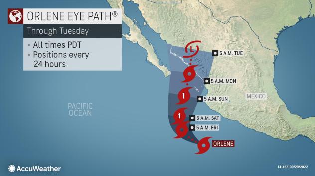
In the coming days, forecasters say Orlene is set to become better organized and gain more strength as it churns off Mexico’s southwestern coast. As the weekend begins, Orlene is likely to become the season’s ninth hurricane.

Impacts to land are set to begin as early as Friday night. The outer rainbands of Orlene will begin to brush coastal areas Friday night and will continue to spread over portions of western Mexico over the weekend.
“Widespread 2-4 inches (50-100 mm) of rain will be possible in the states of Sinaloa, Durango and Chihuahua,” AccuWeather Meteorologist Alex DaSilva said.
In the higher terrain, heavier rainfall can occur with an AccuWeather Local StormMax™ of 10 inches (250 mm).
While these regions of Mexico are not strangers to rain, Orlene can unload close to a month’s worth of rain in some areas over the course of just a few days. This level of rainfall can quickly lead to flash flooding concerns as well as the risk of mudslides in the higher terrain.

The worst impacts in Mexico from Orlene are set to arrive over the weekend as the cyclone takes a turn toward the coastline and begins its approach.
Widespread wind gusts of 40-60 mph (60-100 km/h) are expected across portions of Durango, Nayarit and Jalisco. Stronger wind gusts of 60-80 mph (100-130 km/h) are likely across a large swath of Sinaloa and portions of Durango.

Orlene is forecast to be a hurricane as it approaches the coast late this weekend, but forecasters are concerned that hostile environmental concerns will cause the storm to lose a bit of wind intensity before landfall Monday morning.
Regardless of designation at landfall, the strongest wind gusts will occur near where Orlene slams into Mexico, with an AccuWeather Local StormMax™ of 100 mph (160 km/h).
Given the potential for heavy rainfall and damaging wind gusts, Orlene is a 1 on the AccuWeather RealImpact™ Scale for Hurricanes in Mexico.

The last time a hurricane churned in the basin was back in early September when Hurricane Kay brought torrential rainfall to Mexico’s Baja Peninsula and went on to cause significant flooding in portions of the far southwestern U.S.
While Orlene is set to take a much different track than Kay, forecasters say some moisture from the cyclone can creep into the Southwestern states over the next several days.
“The track of Orlene once it nears Mexico will influence how much – if any – of its moisture makes its way into the U.S.,” AccuWeather Senior Meteorologist Dan Pydynowski cautioned.
The wind direction at the middle levels of the atmosphere will allow some moisture from Orlene to travel into portions of the Four Corners region as early as this weekend.
“It’s not out of the question some moisture gets into southern Arizona,” Pydynowski added.
This moisture can serve to enhance downpours in any thunderstorms that manage to develop across the region. Given the desert climate, any downpour can lead to dangerous flash flooding concerns.
Produced in association with AccuWeather.
The Western Journal has not reviewed this story prior to publication. Therefore, it may not meet our normal editorial standards. It is provided to our readers as a service from The Western Journal.
Truth and Accuracy
We are committed to truth and accuracy in all of our journalism. Read our editorial standards.
Advertise with The Western Journal and reach millions of highly engaged readers, while supporting our work. Advertise Today.


