Nicole To Blast Southeastern US With Rain, Wind And Severe Thunderstorms

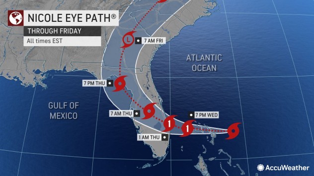
After Nicole tears across the Florida Peninsula on Thursday, the storm will turn northward and track across the interior part of the southeastern United States as a tropical depression and eventually a potent wind and rainstorm from Thursday night to Friday, AccuWeather meteorologists say.
The impacts that Nicole will bring are likely to range tremendously. The storm will deliver beneficial rain to drought-plagued areas, but also life-threatening conditions such as flooding and damaging tornadoes.
Nicole is forecast to touch the Gulf of Mexico briefly Thursday evening before pushing across northern Florida and Georgia Thursday night.

Heavy rain and strong wind gusts will race northward well ahead of the storm’s center from Thursday to Friday. A large swath of rainfall ranging from 2 to 4 inches will stretch from central and eastern Georgia to the western and central portions of the Carolinas, eastern Tennessee, southwestern Virginia and southeastern Kentucky.
Much of the rain will fall within a six- to 12-hour period and could even occur in six hours or less in some cases. This means that rainfall rates of 1-2 inches per hour are possible, which can cause small streams to rise rapidly and spill over their banks, forecasters say. The risk of small stream flooding is greatest in the Appalachians, where pockets of 4-8 inches of rain can fall, but some areas could receive an AccuWeather Local StormMax™ of 15 inches.

Urban flooding is a certainty, especially where fallen leaves clog storm drains. Experts say motorists should be prepared for significant delays and allow travel extra time on the highways and during the morning and evening commutes in cities such as Atlanta and Charlotte and Greenville, South Carolina.
On Nicole’s eastern flank, in the zone of warm and humid air, enough energy will exist to allow severe thunderstorms to develop. These storms will be capable of triggering powerful wind gusts, a few tornadoes and waterspouts from northeastern Florida to southeastern Georgia, as well as the central and eastern portions of the Carolinas from Thursday night to Friday.

A number of severe storms can occur after dark, which will add to the danger.
Forecasters urge people to keep up-to-date with the changing weather conditions and have the means to receive audible alert notifications when they sleep in order to have sufficient time to seek shelter, if necessary.

Wind gusts from 40-60 mph near the Interstate 85 corridor to the Atlantic coast can be strong enough to knock down poorly rooted trees and break weak tree limbs. Because of this, sporadic power outages are likely near and to the east of Nicole’s track over the interior Southeast.
Even though Nicole will track well inland, coastal flooding and beach erosion from Georgia to the Carolinas may continue until the weekend. Winds from the south and southeast cause a significant amount of water from the Pamlico and Albermarle sounds to back up into the tidal river systems in North Carolina. The combination of heavy rain and above-normal tides can lead to flooding in Charleston, South Carolina, into Saturday.

On a positive note, rainfall from Nicole will generally move away from the Southeast by this weekend, which will allow outdoor activities ranging from storm cleanup to sporting events to proceed. Travelers are advised, however, that some roads may remain closed in the immediate wake of the storm due to fallen trees, washouts or ongoing high water.
Chillier air will press into much of the region this weekend in the aftermath of Nicole.

It is possible that rain from Nicole could also greatly wipe out much of the drought that has prevailed across the region as runoff from Nicole’s rains will provide a boost in reservoir and lake levels. According to the U.S. Drought Monitor, drought conditions range from abnormally dry to severe in the Southeast.
Nicole will continue to race along across the interior Northeast from Friday to Saturday and will bring similar impacts to that region.
Produced in association with AccuWeather.
The Western Journal has not reviewed this story prior to publication. Therefore, it may not meet our normal editorial standards. It is provided to our readers as a service from The Western Journal.
Truth and Accuracy
We are committed to truth and accuracy in all of our journalism. Read our editorial standards.
Advertise with The Western Journal and reach millions of highly engaged readers, while supporting our work. Advertise Today.


