Brief Warmup Will Collapse To Winterlike Chill In Midwest

After a cool start to the weekend, temperatures may rebound slightly in the coming days. However, AccuWeather meteorologists caution that another widespread cooldown is on the way for the Plains and Midwest.
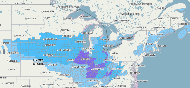
Not long after the official start of fall, temperatures have quickly adjusted downward across much of the Midwest and northern Plains. While these temperatures have been far from what the core of winter will eventually bring, it has been a noticeable change for millions and was even enough to bring the season’s first snowfall to a few locations.

Early on Saturday morning, chilly air was already in place across much of the Midwest and northern Plains with the lowest temperatures so far this season. While the urban heat island effect has kept subfreezing temperatures out of cities such as Chicago and Detroit, other locations have been meaningfully chillier with frost and freeze alerts spanning across a large section of the United States. Smaller cities such as Grand Rapids, Michigan, and Sioux Falls, South Dakota, had reached below the freezing mark overnight, with both locations recording their coldest nights of the fall so far.
Farther north, the cooldown felt even more like winter in some areas. In the Upper Peninsula of Michigan, a combination of lower temperatures and moisture from Lake Superior combined to produce lake-effect precipitation, which fell as snow for several hours in locations such as Marquette and Houghton, Michigan. While temperatures were just far enough above freezing to avoid any accumulation, it was a massive change from the weather conditions around a month prior, when temperatures surged to 90 degrees Fahrenheit on the peninsula.
Over the next few days, temperatures are expected to edge back up slightly, thanks to a sprawling area of high pressure over the eastern half of the country.
“While the center of the high pressure is located right overhead on Saturday, it will begin to drift eastward to start the new week. Since winds flow in a clockwise pattern around areas of high pressure, this will pull up warmer air from the south, helping to boost temperatures,” AccuWeather Meteorologist Alex DaSilva explained.

This change will first be felt across the northern Plains on Saturday, with high temperatures reaching well into the 60s in the Dakotas. A few spots may even flirt with the 70-degree mark, as generally sunny skies help to nudge afternoon temperatures upward. Farther east toward the Great Lakes, where the cooling influence of the high pressure system will hang on longer, temperatures in the 50s to near 60 F will be more common.
On Sunday and Monday, the warmth will be even more pronounced. Cities such as Detroit and Milwaukee are likely to reach the 60s once again, with highs in the 70s more likely along the heavily traveled Interstate-80 corridor. Farther south still, temperatures may feel more like summer than October, with highs near or over 80 degrees in Omaha, Nebraska, and St. Louis.

By midweek next week, however, a major change will get underway.
“As a fast-moving cold front swings through, the warm air mass will be replaced by one originating from the polar regions of Canada,” DaSilva said, noting that temperatures could quickly crash by 20 degrees or more in some areas.
This change will first be noticed on Wednesday in North Dakota, and portions of Minnesota. Temperatures in the 50s are expected in these areas, compared to the 70s a day prior.
By late week, temperatures may fall even further. The majority of the Midwest is expected to remain in the 50s for high temperatures, with the northernmost portions of the Great Lakes struggling to leave the 40s. Overnight lows will be plenty chilly as well, with cities such as Minneapolis and Chicago potentially having the mercury dip below freezing. Farther north in the typically colder spots, lows in the 20s are more likely.

Much like the last cold front to swing through the area, only spotty precipitation is expected, and many locations may stay entirely dry. However, a few specific areas may get cold enough to have some snowflakes, should any precipitation head their way.
“Along the Canadian border in North Dakota, and Minnesota, a few snow showers can’t entirely be ruled out. Additionally, lake-effect rain could briefly turn to snow in portions of northern Michigan,” DaSilva said, though noting that ground temperatures would likely be too warm for accumulation to occur.
Unlike the first wave of cold air, there are signs that this one will be here to stay for some time, with chilly conditions possibly lasting into next weekend.
The persistent dry weather across the area is likely to worsen drought conditions across the Plains and into the Great Lakes. Much of North and South Dakota, Minnesota, Iowa, and Nebraska, are abnormally dry or are in a moderate drought, according to the U.S. Drought Monitor. A few areas, like near Sioux City Iowa, and Sioux Falls, South Dakota, to near the Twin Cities in Minnesota, are even in severe or extreme drought. Abnormally dry conditions, albeit spottier in nature, extend into portions of Wisconsin, Michigan, and Illinois, as well.
Produced in association with AccuWeather.
The Western Journal has not reviewed this story prior to publication. Therefore, it may not meet our normal editorial standards. It is provided to our readers as a service from The Western Journal.
Truth and Accuracy
We are committed to truth and accuracy in all of our journalism. Read our editorial standards.
Advertise with The Western Journal and reach millions of highly engaged readers, while supporting our work. Advertise Today.


