A New Tropical Storm May Rapidly Develop In The Gulf Of Mexico
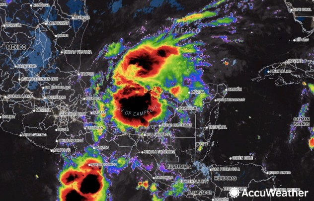
An area of disturbed weather in the southwestern Gulf of Mexico that AccuWeather meteorologists have been concerned about since last week may evolve into a tropical depression and storm as early as Wednesday.
As Hurricane Julia was closing in on Central America late last week, AccuWeather meteorologists warned that leftover energy from Julia could lead to the formation of a new tropical system in the southwestern Gulf of Mexico as well as off the Pacific coast of Mexico. On Monday, Julia became the second tropical storm of the season to survive the trip from the Atlantic to the Pacific Ocean – the first time on record that two storms have crossed over in one season. The first storm was Bonnie which traveled from the Atlantic to the Pacific from late June into early July.
Julia became a tropical rainstorm Monday and has since dissipated. In the storm’s wake, a second development area that forecasters warned about was becoming more noticeable offshore of Mexico over the Pacific Ocean.
The National Hurricane Center (NHC) said a hurricane hunter aircraft will investigate the disturbance Tuesday afternoon. Tuesday morning, NHC designated the disturbance as Invest 93L to ramp up the investigation pertaining to the system.
The southwestern Gulf of Mexico system is an area where a budding system could rapidly develop, forecasters warn.
“There is an increasing amount of moisture in the southwestern Gulf of Mexico as evidenced by the eruption of thunderstorms in the region,” AccuWeather Chief On-Air Meteorologist Bernie Rayno said. “There is also a bubble of high pressure in the upper portion of the atmosphere right over the top of the zone, which could allow more thunderstorms to erupt and strengthen.”
Because of these factors and several others, AccuWeather meteorologists believe there is a high risk of tropical development in the southwestern Gulf of Mexico from Wednesday to Friday.

“The next phase to watch for is a circulation with the growing cluster of thunderstorms,” Rayno said.
Warm water temperatures are one key to tropical development in this area.
Meteorologists don’t just look at surface water temperatures, they also study the water temperatures farther down in the ocean when determining whether a system will strengthen or not. Water temperatures of about 78 degrees Fahrenheit or greater are needed to foster development and sustain a tropical system.
“Surface water temperatures are well into the 80s F throughout the Gulf of Mexico, and that will help with development in the short-term, AccuWeather Meteorologist Alex DaSilva said. “However, deep down, water temperatures are in the lower 70s and could percolate toward the surface due to upwelling soon after a storm forms and begins to agitate seas.”
Light winds currently surround the thunderstorm zone and are another factor that favors development in the short term. When winds are light outside of the targeted development zone, circulation can have an easier time when trying to organize.
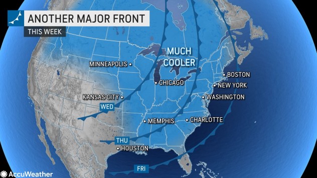
Toward the end of the week, strong breezes, known as wind shear, are forecast to increase throughout the region. The shear will increase as a cold front drops southward into the Gulf of Mexico.
Weak wind shear can further foster tropical development under certain conditions, but strong wind shear usually disrupts the circulation of brewing or established tropical systems and can often lead to their demise.
The combination of increasing wind shear, upwelling and land interaction with Mexico should limit development or lead to quick weakening at the end of the week following a period of rapid strengthening beforehand.
The feature is likely to move very little over the next few days and does not appear to be a direct threat to the United States. However, it has to be watched closely because forecasters note that steering breezes can change over time.
While increasing wind shear and upwelling could cause the system to diminish in place over the southwestern Gulf, the system could wander onshore in Mexico prior to any weakening. In this case, torrential rain and gusty winds could pose a serious risk to lives and property in the region.
Regardless of whether the system reaches strong tropical storm status or not, seas will build in the southwestern Gulf of Mexico. Depending on how much strengthening occurs, seas and surf may then become more intense.
If the system does reach tropical storm strength, which is when a storm has a clear center of circulation and maximum sustained winds reach 39 mph, it will be called Karl.
Should the system develop into a strong tropical storm or hurricane, even for a brief time, large swells may propagate outward to more of the western and central Gulf of Mexico, where petroleum rigs are located. These swells would then increase the intensity and frequency of rip currents along the Texas coast later this week.
There is some indication that leftover moisture could drift northward this weekend following a potential landfall in Mexico, according to AccuWeather Meteorologist Matt Benz.
“Non-tropical weather features in the western and central U.S. may help to draw the moisture northward and potentially enhance rainfall and thunderstorm activity from southeastern Texas to Louisiana and perhaps Arkansas from Sunday to Tuesday,” Benz said. “The non-tropical systems alone could bring heavy enough rain to lead to localized flooding from New Mexico and Texas to Louisiana early next week.”
Areas from central and northwestern Texas to the lower Mississippi Valley could use a thorough soaking. Soil conditions range from abnormally dry to exceptional drought, according to the latest United States Drought Monitor report.
Whether or not a system takes shape in the southwestern Gulf this week, forecasters caution that hurricane season is not over and officially extends through Nov. 30.
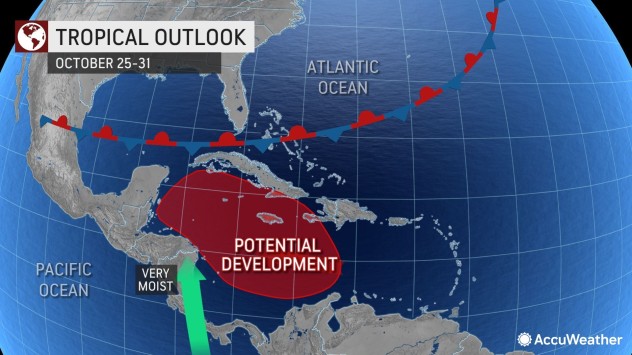
AccuWeather meteorologists will be watching the zone from the Caribbean to the north-central Atlantic during the latter part of October. At least part of this region is usually a hot spot for tropical activity during the latter portion of the hurricane season.
Wind shear is likely to be too strong to allow development from the Gulf to much of the Caribbean and southwestern Atlantic from later this week and into part of next week. However, wind shear may back off in this zone later in the month. Where moisture gathers, there is the potential for a tropical system to brew.
Long-range forecasters indicate that there continues to be some indication of a mid-ocean system that may form later this month over the North Atlantic, perhaps near the Azores.
Produced in association with AccuWeather.
The Western Journal has not reviewed this story prior to publication. Therefore, it may not meet our normal editorial standards. It is provided to our readers as a service from The Western Journal.
Truth and Accuracy
We are committed to truth and accuracy in all of our journalism. Read our editorial standards.

Advertise with The Western Journal and reach millions of highly engaged readers, while supporting our work. Advertise Today.


