Powerful Thunderstorms Threaten Much of US, Torrential Downpours Expected

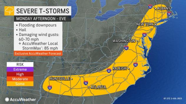
“Following an active evening for severe weather from Tennessee to New Jersey, more dangerous and potentially damaging thunderstorms will fire up from Vermont and New Hampshire, southward to the Carolinas, and westward to Mississippi on Monday,” said AccuWeather meteorologists.
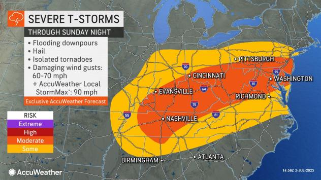
“There have been close to 700 incidents of damaging winds alone from severe weather spanning Thursday, Friday, and Saturday,” said the National Oceanic and Atmospheric Administration (NOAA). As more information comes in from Sunday’s severe storms and what is likely to unfold on Monday, the five-day period may end up with 1,000 cases of damaging winds in the Central, Southern, and Eastern United States.
More than 50 million people in the Eastern and Southern states may have a severe thunderstorm wandering through their neighborhood on Monday afternoon and evening.
Major metro areas at risk for severe weather along Interstate 95 on Monday include New York City, Philadelphia, and Washington, D.C. while the cities of Raleigh and Charlotte, North Carolina as well as Greenville, South Carolina, and Atlanta, could face severe weather. As the storms approach area airports, flight delays due to ground stops are likely to increase.
The greatest threat for those outdoors, as with any thunderstorm, is from a lightning strike. With large numbers of people spending time outdoors due to the Independence Day holiday, forecasters urge people to move indoors at the first rumble of thunder. Tents, golf carts, and picnic pavilions do not offer adequate protection from lightning.
“In addition to the likelihood of sudden, frequent lightning strikes, some of the storms will produce wind gusts between 60 and 70 mph,” said Alex DaSilva AccuWeather Meteorologist.

“At this strength, large tree limbs can break, and poorly rooted trees can be toppled. Where trees interact with utility lines, local to regional power outages are possible,” DaSilva stated,” Severe storms on Saturday knocked out power to more than 200,000 utility customers from the middle Mississippi Valley to the Southeast states,” said AccuWeather.
Because of the great amount of moisture in the air, the towering clouds from the thunderstorms will unleash torrential downpours that suddenly drop visibility. In a matter of a few minutes, runoff can turn streets into raging torrents of water for several minutes, and water can collect in areas that drain poorly. Campers along small streams, especially over the southern Appalachians, should closely monitor heavy rain in the vicinity as runoff from a downpour far upstream can lead to a rapid rise in water levels at their site.

A few incidents of a pea to marble-sized hail are possible with the strongest storms as well.
A sea breeze that develops along the coast may offer some protection from thunderstorms at most beaches during the midday and afternoon hours. However, there can be some exceptions. When a sea breeze is present and thunderstorms build inland, often the storms hold off until the evening or nighttime hours before reaching the beach. Sporadic morning showers may occur as the sea breeze develops and wanders a few miles inland.
Just enough dry air is forecast to push in from the Great Lakes and Canada to prevent thunderstorms from erupting over much of the Northeast on Independence Day.
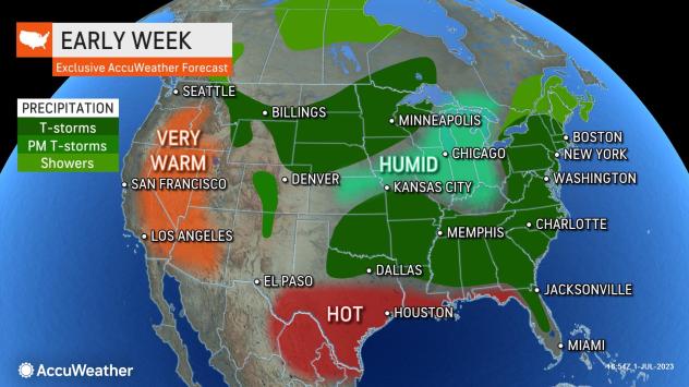
“However, a broad ribbon of moisture, where heavy to locally severe thunderstorms may occur from around the Delaware Bay region to the lower Mississippi Valley. Storms in this zone will likely be drenching and locally gusty with the potential for sudden lightning strikes. Most of the storms will tend to occur during the afternoon and evening hours, “said AccuWeather Senior Meteorologist Matt Benz.
As cool air begins a new southward push from Canada, thunderstorms will erupt along the back edge of warm and humid conditions from Monday to Tuesday over part of the North Central states.
Similar to storms in the eastern and southern U.S. into Tuesday, the greatest threats from the storms will be from sudden lightning strikes, high winds, and downpours.
Some of the strongest storms over the northern and central Plains may produce moderate hail to the size of marbles or golf balls.
Any severe thunderstorm in the Central and Eastern states has the potential to produce a brief tornado or waterspout through Independence Day.
Produced in association with AccuWeather
Edited by Judy J. Rotich and Newsdesk Manager
The Western Journal has not reviewed this story prior to publication. Therefore, it may not meet our normal editorial standards. It is provided to our readers as a service from The Western Journal.
Truth and Accuracy
We are committed to truth and accuracy in all of our journalism. Read our editorial standards.
Advertise with The Western Journal and reach millions of highly engaged readers, while supporting our work. Advertise Today.


