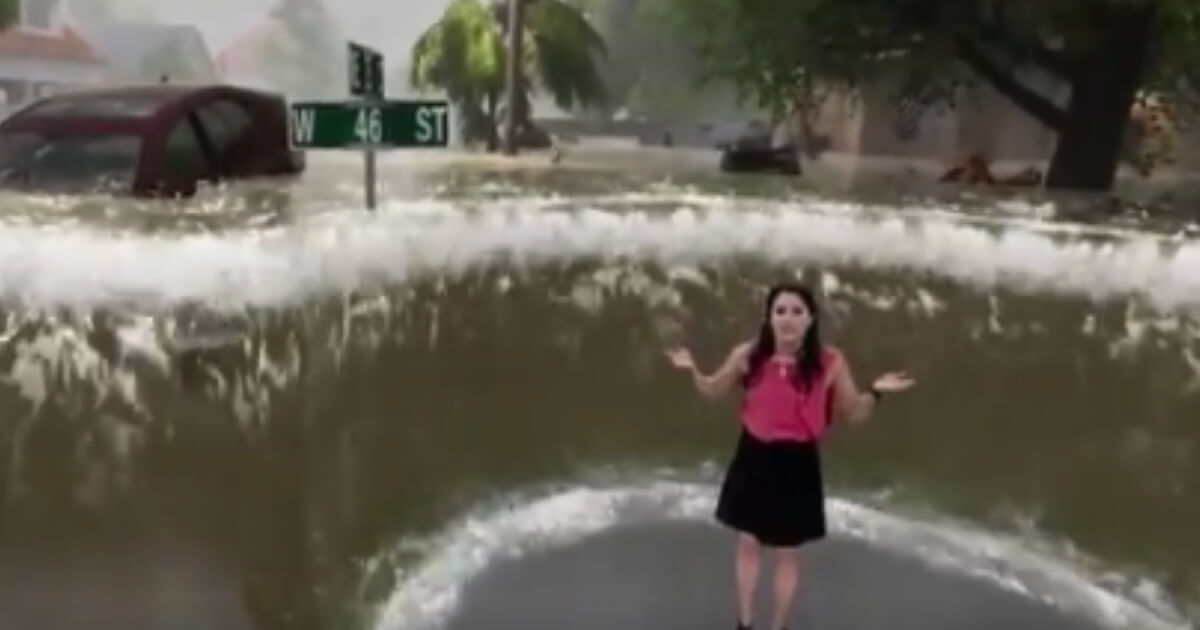
Watch: Weather Channel's Storm Surge Simulator Is as Amazing as It Is Terrifying
Residents of North Carolina and South Carolina, as well as parts of Georgia and Virginia, are battening down the hatches in preparation for the landfall of Hurricane Florence, if they haven’t already evacuated the area.
The Category 2 hurricane, which thankfully didn’t live up to the Category 5 predictions from earlier in the week, is expected to inflict incredible damage to homes and other structures in its path, and unfortunately will probably claim more than a few lives.
The expected damage and destruction will come by virtue of the strong winds, heavy rains and flooding, some of which will come via the storm surge, the name for rising water levels pushed on shore and up rivers as the powerful storm makes landfall.
The storm surge associated with Florence is described as “life-threatening” and predicted to be as high as 11 feet.
For all of the talk and dire predictions about the dangers of the storm surge, the true impact of what a storm surge looks like and can do is lost on many who simply are incapable of visualizing the effect of a sudden surge of water rising on their quiet neighborhood street or around their home.
In light of that, The Weather Channel put together a rather dramatic visualization of what a storm surge would look like using the latest technology and computer graphics.
Storm surge will be a huge factor for Hurricane #Florence Check out what it might look like with @TWCErikaNavarro: pic.twitter.com/TPqTZTmiAM
— The Weather Channel (@weatherchannel) September 13, 2018
Twitter user Brian Kahn described it as “an amazing and sobering use of technology to show what hurricanes like Florence can do.” In a follow-up tweet, he added, “I feel like I understand storm surge academically, but this really drives it home what the forecast means and why coastal evacuations were mandatory.”
The video is indeed quite a powerful depiction of the very real dangers associated with a storm surge coming ashore along with a hurricane.
Using computer-generated graphics, meteorologist Erika Navarro showed how a three-foot storm surge would be enough to knock her off her feet in the swirling and fast-moving waters.
Once the surge rises toward the six-foot level, it would be enough to lift and float cars and other large or small pieces of dangerous debris — which could include downed power lines, toxic chemicals, sewage, animals or even snakes — would nearly cover street signs and would certainly be over top of the heads of most people, who would be incapable of standing or staying in one spot in the swiftly swirling waters.
With a nine-foot surge, Navarro showed how she would be absolutely dwarfed by the computer-generated wall of water around her. Flood waters that high would almost certainly have swamped the first floor of most houses, perhaps even reaching the second floor of some.
“This is an extremely dangerous and life-threatening situation, so if you find yourself here, please get out. If you’re told to go, you need to go. Listen to those local officials and make sure you heed their advice if told to do so,” Navarro said.
The computer-generated visualization of the sheer power and utter danger of the predicted storm surge is amazing in its use of technology, but this actually isn’t the first time The Weather Channel has produced a video with stunning dramatization.
In June, the network produced a similar video featuring meterologist Jim Cantore standing amid the destructive power of a computer generated tornado that increased in power from an EF-2 to an EF-5, making it appear as though Cantore was dodging flying debris like wrecked cars and falling power line poles.
The use of this technology to really drive home the dangers of a storm surge or tornado in a way that helps people visualize what will actually happen is a tremendous benefit to those who may not fully pay attention to storm predictions or think they can “ride out” a dangerous storm.
Hopefully the people in the path of Florence took the advice of local officials and weather experts and evacuated the areas predicted to be hardest hit. We certainly hope and pray that nobody has to experience the nightmare of a storm surge like the one depicted in the video.
Truth and Accuracy
We are committed to truth and accuracy in all of our journalism. Read our editorial standards.
Advertise with The Western Journal and reach millions of highly engaged readers, while supporting our work. Advertise Today.


